Dunes and Dust in Arabia Terra
The battered region of Arabia Terra is among the oldest terrain on Mars. A dense patchwork of craters from countless impacts testifies to the landscape's ancient age, dating back billions of years.
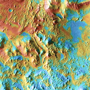
In eastern Arabia lies an anonymous crater, 120 kilometers (75 miles) across. The floor of this crater contains a large exposure of rocky material, a field of dark sand dunes, and numerous patches of what is probably fine-grain sand. The shape of the dunes hints that prevailing winds have come from different directions over the years.
This false-color image, made from frames taken by the Thermal Emission Imaging System (THEMIS) aboard NASA's Mars Odyssey orbiter, shows the center of the crater's floor. The image combines a daytime view at visible wavelengths with a nighttime view at infrared (heat-sensing) wavelengths, thus giving scientists clues to the physical nature of the surface.
Fine-grain materials, such as dust and the smallest sand particles, heat up quickly by day and cool off equally quickly at night. However, coarser materials - bigger sand particles, gravel, hardened sediments, and rocks - respond more slowly to the same daily cycle.
This means that when THEMIS views these coarse materials late in the martian night, they appear warmer than the pools and patches of fine-grain sand. In the image here, areas that are cold at night appear in blue tints, while the warmer areas show in yellows, oranges, and reds.

Sculpted Dunes
The dark sand dunes, probably made of basalt grains, have a shape that indicates the main winds forming them blew from the northwest (upper left). Yet their "fish-scale" pattern indicates the winds varied somewhat in direction.
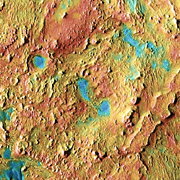
In this close-up view, the advancing dunes have partly engulfed rocky knobs and hills. In the large image, the dunes trail off toward the northwest, making a smooth slope down into a small depression on the crater's floor. In the northeastern (upper right) part of the large image, a few dunes have made a flanking maneuver around the large central hill.
Winds give dunes an asymmetrical shape: sand grains bounce and roll up a long, gradual face until they reach the dune's summit. Beyond the summit, the wind slackens and the grains drop through quieter air to build a steep face that looks downwind. These dunes' highest points stand about 200 to 250 meters (650 to 820 feet) higher than at the foot.
The yellowish color on the southwestern dune faces suggests that the dune sands are warmer on that side. This may indicate on that side that larger particles are holding residual warmth lingering from the afternoon Sun. A more interesting possibility is that these dune faces are fresher - meaning that local winds have shifted to blow from the northeast, and in places winds have exposed coarser sand.
Central Peak
The hill in the center of the large image also lies in the center of the unnamed crater. It may be the remains of a central peak formed during the impact that blasted the 120-km crater, or perhaps it's a pile of sedimentary material. At its highest, the hill reaches about 800 meters (2,600 feet) above the crater floor.
Yet one look at it reveals many reddish areas where rocky and coarse-grain material is exposed - and much of it is a geological jumble. Small ridges and lines of tiny hills meet, curve, and intersect in complex ways. Whatever the hill's origin, untangling the geology in detail will not be easy.
Patches of blue indicate where deposits of fine-grain sand have collected. Many of the patches, both here and elsewhere across the large image, occupy low spots and depressions. But not all. In the southeast (lower right) part of the main image, the fine sand also blankets hills and low mesas.
Eroded Mesas
The eastern side of the large image is almost dust-free, with broad expanses of exposed rock, gravel, and coarse-grained sediments. An older surface lies here, but erosion has reduced it to isolated buttes, rimrock, and small segments of mesa.
The origin of this older surface could be hardened rock that was melted by the heat of impact making the crater. But a lot of time has passed since that occurred more than 3.5 billion years ago. A more likely possibility is sedimentary deposits that filled the crater's floor, caused by changes in the martian climate. These are now being removed by erosion, which is exhuming older and more ancient layers.
A complicating factor in unraveling this crater's story is the presence of the immense shield volcano Syrtis Major. The Syrtis caldera lies about 1,200 km (750 miles) to the southeast, but the volcano's lava flows reach most of the way to this crater. In fact, eroded lavas and wind-blown volcanic ash from Syrtis might be a source for the sand making the dark dunes in the image. Or the dark sand may have eroded out of the crater's floor materials.