Geological Footprints in Ares Vallis
Numerous channels flow northward out of the Martian southern highlands and empty onto Chryse Planitia. These channels saw gigantic floods - as large or larger than any on Earth - early in Martian history. This was a time when Mars likely had a thicker atmosphere and a warmer climate. While Ares Vallis is not the widest or deepest outflow channel, it has a length of nearly 1,600 kilometers (1,000 miles).
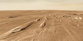
This image shows part of Ares near its channel mouth. It was taken at visible wavelengths by the Thermal Emission Imaging System (THEMIS) on NASA's Mars Odyssey orbiter. In the image, downstream lies toward the upper left, so the floods came from the lower right.
The fresh-looking crater at lower right, however, is a relative newcomer. Named Lins, the crater is 6.2 km (3.9 mi) wide. The impact that made Lins came after the floods were over, and thus the crater preserves intact its original structure - unlike the somewhat smaller, unnamed crater to its left, which clearly felt the effects of flood waters.
In the upstream direction, the Ares channel extends generally southward into the highlands of Arabia. Some 1,200 km (740 mi) upstream from the scene here, Ares connects with Aram Chaos. Aram is an ancient impact crater filled with jumbled mesas and blocks; these point to a catastrophic release of much underground water.
Yet Aram is unlikely to be the sole source of floodwaters in Ares Vallis. Linked to the upper end of Ares lies a chain of craters, depressions, and chaotic terrain connected by narrow valleys and spillways. This network is called by scientists the Uzboi-Ladon-Margaritifer drainage system, and it extends as far as the rim of the large Argyre impact basin, some 3,500 km (2,200 mi) south of this image.

In the Groove
Long, low ridges in the bed of Ares were produced by the scouring floodwaters that eroded the channel. These vary in height, but are typically a few tens of meters (yards) high. The large, streamlined "islands," however, are probably debris deposits. These stand a couple hundred meters high, and were left where obstacles such as craters produced a zone of downstream turbulence that let debris settle and collect behind them.
In July 1997, the Mars Pathfinder spacecraft, and its mini-rover Sojourner, landed 250 kilometers (155 miles) downstream from here (out of the picture to the upper left). The abundant rocks and boulders at the Pathfinder site, and the way some of them appear piled against one another, testify as much as these streamlined mesas to powerful floods.
A lot of water has poured through Ares, but exactly how much is unknown. Estimates give the volume a peak outflow of many times the present-day Mississippi. The water likely came in surging floods (rather than a steady flow) as groundwater was abruptly released in the channel's sources. Ares' history dates, scientists think, from the late Hesperian era, a period ending 2 to 2.5 billion years ago. It was a transitional time as Mars was becoming colder and drier.

Rough Edges
Floods are typically turbulent and those in Ares carried much sediment and debris with them. The distinctive pattern seen here - with ridges and hollows about 500 meters (1,600 feet) apart - somewhat resembles giant dunes. While deep, fast-flowing water can deposit dunes on the floor of a channel, something else may be going on here.
This part of the channel bed lies 500 meters higher than the main channel because it is closer to the northern edge of Ares Vallis. Floodwaters here were shallower, and perhaps deposited more than they eroded. If the debris settled and water escaped from the sediments, it might leave behind such a semiregular pattern.

Wrinkling Up
After the channel bed was last scoured by floodwaters, tectonic activity squeezed this part of Ares Vallis and raised a welt-like wrinkle ridge that runs across the valley almost at a right angle. The squeeze was relatively gentle here because the bump rises only 25 to 40 meters (80 to 130 feet).
The wrinkle ridge was one of the last geological activities to occur here. In the time since the ridge was raised, it has collected only a few fresh craters on it. Yet even though it is recent in Martian terms, the ridge is likely still two billion years old or more. Most of the craters on the ridge appear fairly subdued, thanks to accumulations of wind-blown sand and dust over geological ages.
Geo-Footprints in Ares Vallis