Bath Salts in Candor Chasma?
The great Martian rift valley, Valles Marineris, is such a compelling feature that sometimes it's hard to look beyond the fact that it's the most spectacular hole in the ground anywhere.
Yet if the valley's overall shape and structure have geological stories to tell, its most interesting aspect doesn't concern the steep walls and long, straight troughs. What is attracting scientists most are the nondescript piles and sheets of debris that litter many parts of the valley floor.
One such location is western Candor Chasma. Here the debris piles once earned Candor a place on the list of potential landing sites for NASA's next-generation rover, the Mars Science Laboratory (MSL). The rover's mission goal is finding rocks that may preserve traces of a Martian biosphere. Because water appears essential for life, the highest priority rocks in MSL's search will be those showing evidence of water.
While this site was ultimately not selected for MSL, it still offers scientific attractions to keep it on lists of potential landing sites for future rover spacecraft.
Some debris in Candor, however, would likely be bypassed in a future mission. For example, near the top edge of the large photo, big chunks of broken rock litter the foot of the wall, dumped there by gigantic landslides. This area would be hard for any rover to navigate, and in any case, the rocks' history will be greatly scrambled by the landslide.
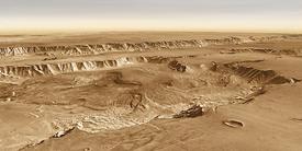
But across the floor of western Candor, which spans about 150 kilometers (90 miles) north to south, lie rolling hills and low mesas, etched by the wind in places into linear streaks.
At first glance the deposits look confusing, chaotic, messy. But high-resolution views from orbital telescopes show areas, such as the edges of mesas, which appear layered and structured. This has earned these heaps the name interior layered deposits, or ILDs for short.
If ILDs are stratified, it's likely they can tell scientists a coherent geological story. But where these geo-pages come in the Martian history book is an open question. If the rover is sent here, it will attempt an answer.
The image shows western Candor in false colors, as seen by the Mars Odyssey's Thermal Emission Imaging System (THEMIS). The colors tell scientists about the nature of the surface materials. Tougher and rockier sediments show in warm to red colors, while looser, sandier, and dustier areas are in greens and blues.
Scientists scouting sites for MSL identified three possible locations within Candor where a future rover might study sediments preserving traces of an early Martian biosphere.

Prime Target
A highly promising site in Candor lies just to the east of a low ridge, or mesa edge, in one of the stratified deposits. While the site isn't pool-table flat, studies show local slopes in many places are only 3° or so. This should be easily trafficable by a rover.
The location also has a nearly eroded circular feature, probably an ancient impact crater. About 12 km (7.5 mi) wide, the crater's rim remnants could be useful for scientists to investigate because they likely expose rocks dredged up from deeper below.
But the most important reason to go to this site is the existence of wide exposures of water-associated minerals at the surface. The OMEGA spectrometer on the European Space Agency's Mars Express orbiter found evidence for hydrated sulfate minerals (perhaps epsomite, a key ingredient in bath salts) and a kind of magnesium sulfate called kieserite. These point to an extensive role by water in the minerals' formation.
High-resolution images from orbit show meter-thick layers in the sulfate-rich deposits. These may have been laid down as fine debris falling from the air or blown in by the wind. They may also have accumulated underwater. In any case, the sulfate signature shows water strongly affected them after they were deposited.

Rough Second
Near the southwest corner of Candor lies a second potential rover landing ground. The overall warm tones, however, show that the surface is rockier and less smooth than in the first site. Still, the OMEGA instrument detected broad areas of sulfates at the surface here as well.
The southern part of the landing area would likely be dominated by debris that fell from the canyon walls. But away from them, the landscape features suggest a material deeply carved by the wind. Geologists call such long, fluted shapes yardangs, and on Earth at least, they point to a relatively soft surface material. What lies in Candor, however, remains to be seen.

Distant Third
The third possible site lies in the northwest corner of western Candor. Like site 2, it is somewhat rough and shows harder surface materials than that at the prime site.
This has both sulfates and kieserites nearby, but fallen wall rocks would have to be sorted through by the rover scientists working remotely from Earth. High-resolution images from orbit point to a lot of low ridges and hills; these could provide glimpses into the layered deposits' strata (and hence their history) - or the ridges could simply pose unworkable driving difficulties.
West Candor is one of several potential landing sites within the vast Valles Marineris rift. Whether this or any of the others will get the nod in the future remains to be seen.
Sulfates in Candor Chasma