Bacolor Crater: Icy Impact in Utopia
When a meteorite strikes at high speed, the impact's energy blasts a crater in the ground and ejects debris in all directions.
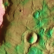
Despite the violence, however, an impact can tell scientists much about the surface where the meteorite struck by the pattern it leaves. For example, Bacolor Crater, 20 kilometers (12 miles) wide, shows many signs that at the time of impact, the subsurface held a lot of water, presumably as ice.
Bacolor lies in Utopia Plantitia, a vast, flat region in Mars' northern lowlands and home to distinctive-looking craters. In 2001, the Gamma-Ray Spectrometer on NASA's Mars Odyssey orbiter mapped abundant hydrogen in the subsurface of Utopia. The data indicate that near the surface, ice makes up 50 percent or more of the volume even now.
Another instrument on Mars Odyssey, the Thermal Emission Imaging System (THEMIS), imaged Bacolor Crater in visible and infrared wavelengths. Combined into a false-color image, THEMIS data can help scientists decipher how much rock, hardened sediments, and dust make up the surface at Bacolor Crater. The data also help them draw a scenario for the crater's formation.
Hot Flow
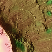
A rough, irregular apron of ejected debris surrounds Bacolor in two layers. A thick inner layer lies almost entirely within the frame of the image. The close-up photo shows part of the layer almost covering a small, pre-existing crater. Scientists think the reason it didn't bury the little crater completely was the flow's slow speed.
Beyond the inner layer lies a thinner, outer layer that extends past the edges of the frame. Scientists studying the details say these layers formed in two separate stages.
The inner layer came first. The impact's heat vaporized the ground and of course any ice where the meteorite struck. Shock waves spread outward from the impact point, smashing rocks and heaving the fragments skyward, along with steam and other hot gases. As the shock wave dug deeper, it excavated a bowl-shaped hole in the ground.
A thick, probably hot, slurry of mud, water vapor, and rock fragments flew away from the growing cavity and fell to the ground, making the inner ejecta apron. The innermost portion of this layer covered the ground thickly and, near the crater rim, shows numerous signs of having flowed at least sluggishly.
Debris Scour
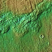
The outer layer formed next. As the inner layer fell like a heavy blanket on the crater's surroundings, the tall column of debris that rose over the impact site began to collapse. As the column fell, it raced outward as a base surge over the inner layer, perhaps even traveling at supersonic speed.
The surge scoured the surface of the inner layer, leaving streaks that radiate from the crater like the spokes of a bicycle wheel. Crossing the edge of the inner layer (see below), the base surge continued outward until it lost its momentum and came to a halt, roughly two crater-diameters from the rim.
Rubble Pile
Where the inner ejecta layer came to rest about one crater-diameter from the rim, it piled up a debris rampart 50 to 80 meters (160 to 260 feet) high. The debris was likely a mixture of broken rock and small fragments, mixed with groundwater, both liquid and solid.
At some time after the inner layer was deposited, the trapped water escaped. This caused the rampart to collapse, spreading the debris a little farther.
As the tortured rocks at the impact site settled in the aftermath, pieces of crater rim collapsed. A portion of the rim (at the 8 o'clock position) slid down into the bowl, leaving a notch in the rim's summit. Likewise, in the 5 o'clock position, another section of rim took a slide, this time outward.
Buried Ice?
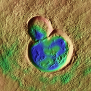
This double crater lies about 14 km (9 miles) to the northeast of Bacolor, surrounded by a field of debris. The blue color of the crater's floor in this false-color image reflects its cold temperature as seen by THEMIS at night. Cold ground can result from two causes.
A layer of dust and fine-grain materials will cool rapidly after sundown, giving up its heat much faster than rocks do. By the time THEMIS flies over late at night, dusty areas have grown very cold by comparison to surfaces where rocks and hardened sediments are more prevalent. The fill within the doublet crater may therefore be a coating of fine materials, left undisturbed by wind thanks to the crater's protecting rim.
Another possibility is that the doublet crater contains material scientists call the Vastitas Borealis formation, which is commonly found across Utopia Planitia. This would indicate the fill is much thicker: tens of meters (yards) thick, instead of a few inches or feet.
Thus the depressions within the doublet crater's fill would have no relation to the formation of Bacolor. Rather, they would be collapse features within this thick layer of material, perhaps as buried ice escapes.