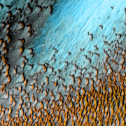
North Polar Sand Sea
A vast sea of dark dunes, sculpted by the wind into long lines, surrounds the northern polar cap of Mars. The dunes appear to be basaltic sand. Taken altogether, the dune field covers 679,000 square kilometers (260,000 square miles) - about as extensive as all Texas.
Looking down from orbit, the THEMIS camera on NASA's Mars Odyssey orbiter captured part of this sand sea in Olympia Planitia, about 300 kilometers (190 miles) from one edge of the polar cap. THEMIS is the Thermal Emission Imaging System, a camera that "sees" in 5 visible and 10 infrared colors.
The image here merges a daytime infrared view with one at visible wavelengths. The visible image records the landscape's details, while the infrared image senses the features' warmth. In this false-color scene, areas with cooler temperatures appear in bluer tints, while warmer features are depicted in yellows and oranges.
Warm Dunes
The dunes appear warm because they are dark gray in color and have absorbed solar heat. Studies suggest the sand grains in the dunes weathered out of basaltic deposits erupted from volcanos, either as lava or ash. The blue-white areas are patches of ground covered with frost.
The dunes, both here and in the large image, have been shaped by winds blowing from the east (upper right). Their long lines developed crests about 500 meters (1,600 feet) apart. Where the long lines become sparser as they approach the edge of the blue areas, they break into crescent shapes called barchans. These, too, give clues to wind direction, as the crescent horns point downwind.
The dune sands are similar in color and properties to a dark base layer that encircles almost all the northern polar cap and may pass completely beneath it. This base layer differs in color, thickness, and composition from the hundreds of fine layers seen within the polar-cap ice. The fine layers are understood to be deposits of dust that settled on the ice from the atmosphere.
According to a study published in 2002 by Caltech's Shane Byrne and Bruce Murray, the dune sands eroded from the base layer at the polar cap's edge. Byrne and Murray suggest the base layer is made of sand that collected in a thick bed across the northern polar lowlands during a time when the ice cap was absent. Then as the martian climate shifted, an ice cap formed on top of this base layer and grew to cover most of the polar sands.
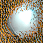
Bright Hill
The ice cap itself may have been far more extensive in the past. The bright spot in this image is a hill that stands about 100 meters (330 feet) above the surrounding plain. The hill is partly within a crater about 9 km (5.5 miles) wide and roughly 70 meters (230 feet) deep.
What the hill is made of is unknown, but one possibility is that it contains ice that collected here when the climate was different. Another possibility is sand or other fine materials piled up by the wind and covered by frosts.
In any event, winds blowing past the hill have deflected around it, breaking the dunes' linear pattern into barchans and creating narrower lines of smaller dunes on the downwind side (lower left).