Fire and Water in Granicus Valles
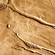
Winding channels snake across the image from right to left, weaving a network that resembles an aerial photo of a desert valley on Earth. Water was essential in carving these channels, which lie on the western side of Mars' Elysium Mons. But volcanic heat was the key to making the water flow, and lava has put its fingerprints on the scene as well.
Elysium is Mars' second big volcanic region, after Tharsis; it lies on the southeast edge of Utopia Planitia, a probable ancient impact basin. Utopia forms part of the vast northern lowlands of Mars, a depression that may have been filled with an ocean or large lakes during one or more stages in the planet's history.
This infrared image was taken in daytime by THEMIS, the Thermal Emission Imaging System, a multi-band camera on NASA's Mars Odyssey orbiter. THEMIS photographs Mars in 5 visible and 10 infrared colors.
Here patches of ground that are warmer appear brighter and darker areas are cooler. In part the brightness variations come from the nature of the surface materials: dust and fine sand heat quickly, while rocks remain cooler. But there's also a lighting effect. Slopes that point south and west - note the channel walls - appear brighter because sunlight is falling on them more directly, warming them.

Floods
The water that eroded the channels burst from pits and grooves partway up the flank of Elysium. As the volcano grew, it pressurized the slopes, forcing meltwater out of the ground through faults that radiate like spokes of a wheel.
According to some geologists, molten rock forcing its way into the faults could have widened them, releasing water. Molten rock could also increase the outflow by melting large quantities of ground ice. However it occurred, the water undermined the surface before flowing away.
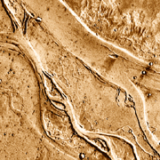
In the large image, the right side shows the volcano's lowest slopes. These descend in a gentle slope to meet the Utopia basin floor along a fault scarp. This lies where the main channel makes a 90° bend to the right before it divides and subdivides its course.

Steamlines
The flows must have contained a mixture of water and volcanic debris, making what researchers call a mudflow, or lahar. On Earth, lahars are usually highly destructive, burying villages and towns when these lie in the flow's path.
How fast these martian lahars flowed is unknown, but they were likely catastrophic in volume. The broad channel shown in the small photo is almost 8 kilometers (5 miles) wide and 150 meters (500 feet) deep, and it slopes downstream about one part in a thousand. (For comparison, the lower Mississippi River is flatter, with a gradient of only one part in 30,000.)
Even on Mars, however, to erode such a large channel on a shallow slope demanded a lot of water and debris.

Sapping
Geologists who studied how the channels cut across one another have concluded that four separate episodes of flooding and channel carving took place. The third of these stages dominates the scene because it cut the deepest.
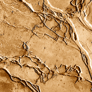
The water responsible for the fourth stage of channel cutting did not come from the volcano's flanks. Instead, it burst out of the ground along the joints and fractures in the basin floor material which form a kind of rectilinear grid.
This fourth stage of channeling created small-scale, linear channels that dissect the larger, often streamlined pieces of ground. But as with the channels on the volcano's flanks, when the water escaped from the subsurface, it undermined the ground and caused it to collapse, a process geologists call sapping.

Fissure
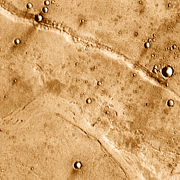
If the Utopia basin once held a large body of water, it was most likely frozen over. One of the best pieces of evidence for such an ice cover is the ridge at the top of the image.
Three kilometers (2 miles) wide, with a height of 40 to 100 meters (130 to 330 feet), and extending for more than 50 kilometers (30 miles) radial to the volcano, the ridge looks at first glance like just another channel. It's not until you observe the lighting closely that it becomes plain this feature is positive, not negative.
To geologists, the ridge resembles similar ones found in Iceland called moberg ridges. (Móberg is the Icelandic term for a kind of weathered, brownish lava.) Moberg ridges form when lava erupts from a crack in the ground that's buried under a thick layer of ice.
The ice melts at the point the lava comes out of the fissure. But in cases where the ice is thick enough, it can confine the erupted lava, leaving a rough-surfaced ridge such as seen at top. The height of this ridge - roughly 100 meters - suggests that the ice covering in Utopia was at least that thick.