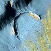
Glacier Flowlines in Mamers Valles
Mamers Valles is a trough that winds for nearly 1,000 kilometers (600 miles) through the ragged highlands of Arabia Terra on Mars, before it empties onto the vast northern lowlands in Deuteronilus Mensae. In the section seen here, about halfway along its course, the valley averages 25 km (15 miles) wide, and its floor lies 1,200 meters (4,000 feet) below the rim.
Scientists think the linear features on the valley bottom are telling a tale of flowing ice covered with a layer of rock.
This image, taken by the Thermal Emission Imaging System (THEMIS), combines images taken in daytime at both infrared and visible wavelengths. It shows daytime ground temperatures using false colors - warmer areas appear in reddish tints, while colder ones are bluer. Ground temperatures are controlled both by the nature of the surface materials and by solar heating. Slopes that face the Sun more directly become warmer, while those turned away are cooler. In addition, surfaces mantled with fine-grain particles (such as dust or fine sand) respond quicker to solar heating, but more cohesive and rocky material stays cooler.
While Mamers Valles dates from the early Hesperian period in Mars' history - about 3.8 billion years ago - the valley floor contains far younger material, perhaps only a few million years old or less. This material is relatively uncratered, and its lineations show that it has flowed from the valley walls toward the channel's center. Then, after merging with the debris from the channel's other side, it flowed along the valley in a downstream direction.
How much ice this lineated fill contains is the focus of scientific debate. Earlier views held that the valley fill was mostly rock with some ice that collected as water slowly infiltrated through the cracks and voids in the debris. More recently, however, many scientists have concluded that the ice is a lot more plentiful, with perhaps a relatively thin covering of rocky debris. If so, these features would be the Martian equivalent of valley glaciers found on Earth, especially in the Dry Valleys of Antarctica and on Baffin and Ellesmere Islands in the Canadian Arctic.
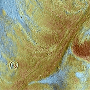
Flowing Debris
This ancient impact crater, about 4 km (2.5 miles) wide, lost half its rim as the heaped-up debris flowed down the slope toward the valley center, probably carried by ice. Scientists think the ice is likely to be a remnant from an earlier climatic period in which Mars experienced an Ice Age.
Over hundreds of thousands of years, Mars' polar axis shifts relative to the planet's orbit. When Mars' axis tilts much more than its current 25°, the polar regions grow warmer and give up water to the atmosphere, while the tropics become colder. By transferring polar water to the tropics (perhaps as snow), water and ice could collect in low troughs like Mamers Valles and form glaciers.
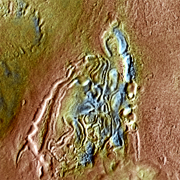
Moraines
Debris flows away from the valley walls, meets and merges in the valley, then flows downstream. Yet this simple picture is complicated by the fact that parts of Mamers Valles have a reverse slope - that is, the channel goes uphill as it proceeds downstream. What causes this?
Mamers is not like a roof gutter with sides that run perfectly parallel; in many places, the valley widens to include old, eroded craters, side canyons, and smaller troughs. Where these join the valley, the debris they contribute to the main flow in Mamers can build up a low rise that locally reverses the overall downstream slope.
The small crater is 720 meters (2,400 feet) across and shows signs of being mantled by the same soft-looking material that blankets part of the valley slopes. The geologic sequence may have been that the crater formed by an impact on the valley floor, and then was covered by snow mixed with dust. Or perhaps the impact struck an already ice-rich rocky surface, and the heat of the impact caused ice and rock to flow into the crater, partly filling it.
Enigma
Scientists have no neat, tidy explanation for this feature, but it is likely to be a pile of rocky debris mixed with ice. As the ice sublimates (evaporates) under the present climatic conditions, this undermines the rock portion, which collapses.
The feature could also be part of an ice-rich debris flow that varied in density. In this case, the grooves in the feature might trace where the ice was richest.