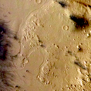
Gusev Crater
This THEMIS visible mosaic, which has been colorized using HRSC imagery, shows the central part of Gusev Crater, the landing site for the Mars Exploration Rover Spirit in January 2004. Gusev is 103 miles (170 kilometers) across and lies just south of the martian equator.
The crater was formed by the impact of an asteroid some 3.5 to 4 billion years ago. Numerous smaller craters dot its floor, the largest being Thira, 15 miles (23 km) wide. The water-carved channel Ma'adim Vallis breaches Gusev's southern wall, and Apollinaris Patera, a large volcano, stands about 100 miles to the north of Gusev.

Columbia Hills
The hills were named for the lost Columbia space shuttle astronauts. The highest peak, Husband Hill, rises about 300 feet (90 meters) above the crater's floor. Spirit's instruments show the rocks in the hills have a varied geologic nature, different from the volcanic basaltic rocks on the crater's floor.
Scientists have several hypotheses for the hills' origin - they may be the eroded remnants of an impact crater's rim or its central peak. Other ideas propose they are a volcanic structure, or a wrinkle ridge, or even a river delta.
Numerous almost-buried craters observed on Gusev's floor lend support to the idea that the Columbia Hills are the remains of an ancient impact crater rim, or possibly a central peak. The hills partly parallel the rim of Thira crater, 9 miles (15 km) to the northeast.
Gusev lies in Aeolis, a region of many craters that contain layered materials. This suggests the Columbia Hills might be the eroded remnants of a once-widespread deposit of material. Besides the Columbia Hills, Gusev contains several more hills scattered across its floor, such as Grissom, White, Chaffee, and numerous other buttes and mesas.
Plains Embayment
Lobes of a smooth material appear to have flowed, perhaps as water-rich sediments or molten lava, across an older, knobby landscape. The older surface is spotted by its pits, knobs, buttes, and mesas. The knobs may have been eroded by winds into fluted shapes called yardangs that trend northwest-southeast.
The smooth plains deposit appears to be composed of many thin layers. While many of the dark streaks on the plains were caused when winds and dust devils removed bright dust, some of the streaks mark where dark material drapes across bright features. These features may be ripple marks or the remnant of an eroded layer.
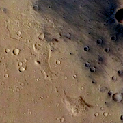
"Little Italy"
Scientists have nicknamed this feature because of its shape. The region lies south of where Spirit landed. The material partly resembles the rough, knobby terrain located on the southeast floor of Gusev. If it has the same origin, then here THEMIS may be looking through a "window" opened by erosion that gives a view down to the older knobby material that is better exposed to the east.