An Ancient Lake in Melas Chasma?
In 2011, NASA plans to launch the Mars Science Laboratory (MSL), a new rover spacecraft with a driving range and instrument payload that greatly improves on the Mars Exploration Rovers Spirit and Opportunity. MSL's task is to assess whether Mars ever had an environment able to support microbial life.
But where should MSL go?
Scientists studied potential landing sites at locations scattering across much of Mars. One site that emerged - but which was ultimately rejected - lies in western Melas Chasma, a corner of the vast Valles Marineris "grand canyon" system that slices across equatorial Mars for thousands of kilometers. (Another possible site lies in eastern Melas, about 450 km (270 mi) away.)
While not chosen for MSL, this site still offers scientific attractions to keep it on lists of potential landing sites for future rover spacecraft.
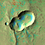
The big image above shows the western Melas landing site, which tucks into a small basin below the south rim of Valles Marineris. While the basin is more than 5,000 m (16,000 ft) lower than the south rim, it still stands 1,200 m (4,000 ft) above the floor of Valles Marineris. Geologists describe such a feature as a "perched basin."
According to research by Catherine Weitz (Planetary Science Institute), Cathy Quantin (National Air & Space Museum), and others, the basin likely contains deposits left when it was once filled with a lake. Even long after the lake waters drained away or dried up, such sediments could preserve evidence of former microbial activity, if it existed.
The image is a false-color mosaic of photos taken by the Thermal Emission Imaging System (THEMIS), a multi-wavelength camera on NASA's Mars Odyssey orbiter. As Mars Odyssey flies in a near-polar orbit, THEMIS scans almost all of Mars, capturing its surface in 5 visible colors and 10 infrared ones. This mosaic is made of infrared frames taken by day and by night.
The false colors hint at the nature of the ground surface. Rusty tones show where rocks and hard deposits abound, while greens and blues indicate the areas where gravel, fine sand, and dust particles predominate.

Bathtub, with Ring
The rover landing site lies centered in this closed, oval basin that measures roughly 20 x 30 km (19 x 12 mi). The little crater at left center spans 1.4 km (4,600 feet), making it slightly larger than Meteor Crater in northern Arizona. Engineers figure that MSL will have a minimum driving range of 20 km (12 mi), so nearly all the basin should lie within the rover's reach, unless the ground proves too rough to drive on.
The swirling lines, reddish-brown in false color, mark where hardened sediments lie exposed at the surface. The curves suggest a complex pattern of outcrops, heavily sculptured by erosion. Calculations show the basin could hold about 160 cubic kilometers of water - roughly one-third the volume of Lake Erie, the smallest of the Great Lakes. The basin has a maximum depth of about 300 meters (1,000 ft), but most of it would have been much shallower.
If the lake behaved like Earth's desert lakes (such as Utah's Great Salt Lake), the waters could have come and gone several times in succession, as changes in the Martian climate waxed and waned.
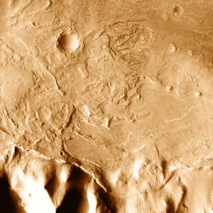
Zooming in on the basin's west end using THEMIS visual-wavelength images - five times sharper than the infrared images - a complex array of deposits (see inset at right) comes to light. (For orientation, note the crater visible in both images.)
The basin floor slopes down from the west (left side), and Mars geologists argue that the carved and sinuous terrain is the remains of a fan of debris washed into the lake. Channels interweave across each other, with softer sediments eroding and leaving tougher deposits standing high. (A smaller fan spills into the closed basin on its eastern end.)
At the foot of the south rim's slope (bottom of the inset frame) lies a possible high watermark, or beach deposit. This can be traced around the basin's perimeter at an elevation of -1,540 meters (-5,050 ft). Such deposits, as well as both debris fans, would be highly valuable for a rover to examine.

At a Watershed
To the west of the little basin lies a feature commonly seen on Earth, but less so on Mars. Running from upper right to lower left across the zoomed-in image at left is a watershed, a divide between two adjacent drainages. While Earth's active hydrosphere gives it uncountable numbers of drainage systems, scientists have found fewer on Mars, which gives this one considerable interest.
The branching valleys on the east side of the divide slope down into the basin where MSL may be targeted, while those to the west slope in a westerly direction. The height of land between the two stands 4,600 meters (15,000 ft) below the south rim of Valles Marineris.
Water that flowed west from the drainage divide formed what geologists call a mature drainage system - channels, branches, and tributaries are all well developed. On Earth, such features typically emerge after about a thousand years of erosion. (The valleys also appear more deeply cut than those that lead into the closed basin on the east.) The west-flowing waters went down onto the main floor of Melas Chasma, carrying sediments onto the big valley's floor.
So where did the water come from? In their branching form, the valleys resemble what develops when rain falls on the ground and runs off unhindered. This remains the most plausible explanation, and it suggests that in Melas at least, ancient climatic conditions allowed for rain.

Outcrop
A low ridge cuts across the floor of Melas Chasma and slices through part of an impact crater 9.6 km (6.0 mi) wide. The rusty tint indicates (in THEMIS' false colors) that here lies exposed a resistant outcrop of rock or hardened sediments - in fact, the outcrop forms part of the crater's southern wall.
A light coating of sediments covers most of the Melas Chasma floor, but not so thickly as to bury the debris apron that surrounds the crater. This has multiple lobes with upraised outer edges. Planetary geologists have concluded that such features show the ground was saturated with water (or ice) when the impact occurred. Larger and more complex examples of this phenomenon are Tooting and Bacolor craters.

Double Whammy
Telescopic and radar surveys of asteroids have found that a sizeable number of them are actually double objects. Some are two separate bodies locked in mutual orbit by gravity, while others are better described as two big rocky lumps in contact.
With Mars orbiting the Sun close to the asteroid belt, it's not surprising to find impact craters that clearly formed when a double-object struck. This double crater measures about 9 x 18 km (6 x 12 mi) and even shows traces of a butterfly pattern in its ejecta apron.
Such patterns are common in two cases: when a meteorite strikes at a very shallow angle and when double-asteroids impact.
Vital Statistics

HIGH WATER MARK
Seen close up, the debris fan at the west end of the closed basin shows a complex history of deposition and erosion. Beach sediments may lie where the basin meets the southern wall of Melas (bottom). Such deposits could preserve traces of former microbial life - if Mars had any. Click on the image to download a 834KB high-resolution version.
NASA/JPL/Arizona State University
Download Original