Galaxias Fossae: The Fire Below
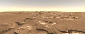
Ruler-straight, the channel named Galaxias Fossae slices across the plains of Utopia on Mars for more than 400 kilometers (250 miles). At first glance, it looks almost artificial - like a sunken Martian freeway or some strange planetary surgical scar.
Numerous channels cut into the northwest flank of Elysium, home to a large volcano, Elysium Mons, and a smaller sibling, Hecates Tholus. Many channels meander across a broad slope that descends from the volcanic summits toward the northwest. These include Granicus Valles, Hrad Vallis, Tinjar Valles, and others.
But Galaxias Fossae is unlike these. They were cut by flowing water released in the wake of gigantic flows of ash and lava, while Galaxias appears to have been born in a different way. Galaxias Fossae may mark the trace of a volcanic dike.
A dike is the name geologists give to a ribbon of molten rock that forces its way into a vertical crack in the crust and widens it. If this theory is right, Galaxias reflects the volcanic activity of Elysium, but it illustrates a different eruptive style than most of the region does.
This image, colorized to resemble Mars, is a mosaic of photos taken at visible wavelengths by THEMIS, the Thermal Emission Imaging System, a multi-band camera on NASA's Mars Odyssey orbiter. In operation since early 2002, THEMIS scans Mars in 5 visible and 10 infrared "colors."
Hot Blade?
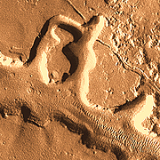
The crack, or geologic fault, that set the course of Galaxias Fossae appears to have been caused by the growth of the Elysium volcanoes. The region's crust ballooned as molten rock rose from below; the ground stretched a little and cracked.
Into the fault, a thin ribbon of molten rock forced its way like a knife-edge, widening the fault and bringing hot rock close to the surface. There it encountered ground saturated with water and ice. The hot rock in the fault melted the ice, and the ground collapsed along its course.
The escape of water triggered more collapse in areas away from the fault line, thus creating a network of channels and isolated mesas. Individually, the biggest channels are about 100 meters (330 ft) deep, but side channels are shallower. Overall, the elevation of the main channel floor drops gently toward the northwest (upper left).
An alternative model for the formation of Galaxias omits the molten-rock dike, but reaches much the same end result. In this model, activity of the geological fault alone was enough to let subsurface water escape and undermine the surface.
It may take a field trip to Galaxias by some future Mars spacecraft to settle the question. But given the volcanic nature of the Utopia region, a dike appears a more likely origin.
Saturated Ground
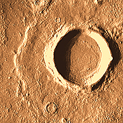
Water and ice in the ground have left fingerprints all over Utopia. Like the pedestal craters seen elsewhere in the region, this "rampart crater," 3 km (2 mi) wide, has features caused by subsurface water.
The key detail is the upraised outer lip on the debris ejected from the crater. Impacts into dry ground typically show an ejecta apron that feathers down to nothing at greatest extent. The elevated lip here suggests that the debris flow was lubricated by groundwater released in the impact.
The debris initially raced outward in a mix of broken rock and dust combined with water and steam. But the flow abruptly halted at a distance of about one crater radius, piling up a low rim some 10 meters (30 feet) high. This occurred where the water escaped from the leading edge of the debris flow. As a result, friction within the flow abruptly increased, and the flow came to a quick halt.
Ash and Mud
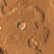
Utopia's volcanoes erupted numerous times, sending flows of lava and clouds of hot volcanic ash spreading far across the northern plains. Following the gentle downward gradient to the northwest - into what is probably the remains of an ancient impact basin - the flows from Elysium Mons reached a distance of 2,000 km (1,200 mi).
Here, we see stubby toes from a flow that has all but engulfed several craters. Such a flow might contain lava and hot ash alone, or it could include water (as steam). The flow front is about 10 meters (30 feet) high, and the overlap of the toes indicates the flow had at least two stages.
In THEMIS images, much of Utopia shows a relatively smooth surface compared to other areas of Mars. It's as if the ground is widely blanketed by deposits that hide some features. Many of the deposits are volcanic in nature.
But perhaps not all. Scientists working with gamma-ray and neutron spectrometers on Mars Odyssey have determined that abundant hydrogen atoms lie at depths of a few feet across this region and others. The most likely source for so much subsurface hydrogen is water, probably in the form of ice.
Thus the picture of Mars that emerges from recent research shows a polar desert: cold and dry at the surface, but with abundant water just below.
Galaxias Fossae