Flooding the Plains of Gold
Together Ares Vallis and its neighbor to the west, Tiu Vallis, flow northward out of the highlands into the broad depression of Chryse Planitia, the Plains of Gold. Both channels were fed by escaping ground water, though from different sources.
Tiu Vallis, which lies on the left side of the big image, connects upstream to a pair of regions where hills and mesas lie jumbled together. Planetary geologists think such "chaotic terrain" shows where subsurface water escaped in one or more outbursts, and the ground collapsed.
Ares Vallis has several sources, among them Aram Chaos, an old impact crater or basin 500 kilometers (300 miles) in diameter.
Aram has drawn much attention since scientists using the Thermal Emission Spectrometer (TES) on the Mars Global Surveyor orbiter found the mineral hematite within the crater's chaotic deposits. Formed in association with water, the hematite points to at least one wet climatic epoch well after the crater's own formation. A small breach in Aram's eastern rim shows where escaping ground water broke through to Ares Vallis and flowed out.
Yet even these sources are unlikely to be the ultimate one for Ares and Tiu. South from Aram runs a long chain of craters, depressions, and chaotic terrain linked by channels and spillways that extends far into the Arabia highlands. Called the Uzboi-Ladon-Margaritifer system, this lengthy channel reaches to the rim of the Argyre impact basin, about 3,500 km (2,200 mi) south from here.
For Tiu, elevation maps show that floodwaters could have poured out of the east end of Valles Marineris. These floods would be fed by escaping ground water and perhaps the draining of hypothesized lakes within Valles Marineris. These waters would have joined with those from the chaotic terrain that fed Tiu more directly.
The stark difference between today's cold, dry Mars and the clear evidence of floodwaters in the past tells scientists that the Martian climate has seen great changes, probably over repeating cycles. Calculations show that the last several million years have seen repeated swings in climate, in which ice ages deposit water (as snow and ice) even near the equator, recharging aquifers and setting the stage for later outbursts that create floods.
Unraveling the workings of that climate history is one of the major challenges in Mars science.
The image here combines frames taken during daytime at infrared wavelengths by the Thermal Emission Imaging System (THEMIS) on board NASA's Mars Odyssey orbiter. Circling Mars in a 2-hour orbit, THEMIS scans the surface in 5 visible and 10 infrared bands. This mosaic records the heat radiation coming from the surface, with warmer areas appearing brighter.
Ground temperature or brightness offers clues to the nature of the surface materials. Exposed to full sunlight, both extremely dark material and fine-grain material become warm, while rockier and lighter-colored material stays cooler.
The irregular, light-colored patches in the two craters at the bottom of the image are probably Sun-warmed fine sand or dust, while the darker areas toward the Ares channel mouth are most likely expanses where large rocks and boulders dominate. Just as in terrestrial deserts, landscapes on Mars mingle together washed-down or windblown debris with outcrops of bare rock.

Removal Services
Scientists don't know how many times floodwaters churned through the Ares and Tiu valleys, and saying how much water was involved amounts to guesswork. Estimates accordingly vary widely, but peak flows probably carried several times the volume of today's Mississippi River.
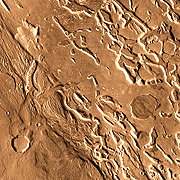
The Ares channel floor lies about 1,100 meters (3,600 feet) lower than its southern rim seen here, while the valley stretches about 80 km (50 mi) wide. However, the Ares channel does not show the meanders and cutoff "oxbow" patterns seen in the Mississippi and other terrestrial rivers that flow in wide, but shallow valleys. The reason is that the Ares flow didn't resemble today's Mississippi or similar rivers.
Instead, scientists argue, the floods were short in duration, large, and violent, doing their erosive work quickly. Some water must have soaked into the ground, but most raced through the channel and poured out onto Chryse Planitia, then flowed farther down into the large northern basin of Acidalia Planitia.
The enigmatic features seen on the channel floor in the close-up image partly resemble chaotic terrain - yet they also look like remnants of a layer dissected by the Ares floods. Small meandering channels that survive among the mesas suggest these were the last floods to flow in the channel.
A closer look at the channel scour marks appears in an earlier THEMIS feature that focuses on Ares Vallis. This earlier feature covers an area on the channel's northern side at right center in the big image here.

Rocky Armor
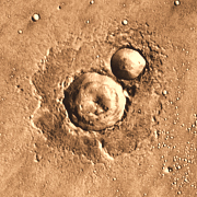
Where two craters nestle together their debris tells a story of violent impacts onto ground that once contained water (or ice). The larger crater spans about 10 km (6.2 mi) and formed first. Had the two formed at the same time, the rim between them would be higher and straighter.
When the impacting meteorite blasted the larger crater, it dug far below the surface, vaporizing or melting the target rock. Ground water flashed into steam and mixed with the shattered and hot rocky debris.
Rocks below the center of the crater rebounded from the shock, raising a conical central peak that now stands 250 meters (800 ft) above the crater floor. Spreading about one crater-radius from the rim is a roughly circular blanket of rocky debris ejected in moments after impact. Its raised outer edge tells scientists that water caught in the debris helped it flow.
The ejecta blanket landed on a surface that contained ground water or ice. This rocky debris threw a rocky armor over the surface, preventing erosion as years passed. Beyond the ejecta's protective cover, climate changes gradually removed water from the ground, letting it erode.
Then the second crater formed by another impact, somewhat smaller. In this case, the meteorite struck a thick layer of shattered rock which had already lost what water or ice it contained in the first blast. Thus the second crater's ejecta blanket lacks the upraised outer rim.

Plain Bumps
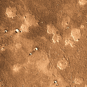
Scientists discovered these enigmatic landforms during the Viking mission in mid-1970s, but no single conclusive explanation for their origin has emerged. Volcanic domes, shield volcanoes, mud volcanoes - no explanation has proven wholly satisfactory.
The mounds amount to geological pancakes. They rise only 15 to 30 meters (50 to 100 feet) high, while they spread as much as 4 or 5 km (2.5 to 3 miles) across. These proportions generally resemble the smallest shield volcanoes on Earth, yet the mounds lie in a region with little other sign of volcanism.
Some appear to have steep flanks, while others merge gradually with the plain they sit upon. Many appear to have uneven upper surfaces, with tiny ridges or peaks.
The dark color of the plain indicates a cool daytime temperature, which suggests the ground is largely covered in big rocks and boulders. The Mars Pathfinder site (see next section) lies not far away, and ground-level images from that spacecraft show lots of big rocks.
In contrast, the mounds' lighter color suggests they are covered in fine-grain material such as sand, which has heated up.

Touchdown Mars
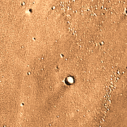
In July 1997, the Mars Pathfinder spacecraft, along with its little rover, the microwave-oven-size Sojourner, set down in the center of this image. The landing site lies between the small crater at lower center and the tiny hill at upper center. (The spacecraft, however, is far too small to be seen in the photo.)
Mission scientists sent Mars Pathfinder here because orbital images showed that floods pouring into the Chryse basin would have overrun the landing site. Indeed, the lander found evidence that floods had sorted and piled up the rocks and boulders at the site. The rover's instruments also found a new kind of rock that resembled a geologically evolved basalt, an important finding.
Scientists sent Pathfinder to test spacecraft systems that could land small packages at carefully chosen sites, thus its mission was by no means as ambitious as the Viking landers from 1976. These two landers were sent specifically to look for life, but negative findings showed that scientists still had much to learn about the Red Planet.
Viking 1 landed on a different part of Chryse about 840 km (520 miles) to the west-northwest from Pathfinder's landing site.
Pathfinder showed that airbags could safely land probes on Mars, and Sojourner proved the value of rovers. A direct result of Pathfinder was the two Mars Exploration Rovers, Spirit and Opportunity. Landing in January 2004, these two have long outlived their original missions and uncovered many more kinds of rocks, contributing to a much-enriched picture of Martian geology.
Yet their wildly successful mission began with one small probe that dropped into Ares Vallis a decade ago.
