Cascading Dunes in Rabe Crater
Rabe Crater lies among hundreds of thousands of other impact craters in the rough-hewn southern highlands of Mars. Spanning 108 kilometers (67 miles), Rabe is halfway between the martian equator and the south pole, and west of the giant impact basin Hellas.
Two features help set Rabe Crater (and several more in its vicinity) apart from most other craters on Mars. Rabe has a flat floor with a pit sunk into it, plus a large field of dunes. According to scientists, the two features may even be related.
A pair of visible-wavelength images together with numerous infrared ones created this false-color THEMIS view that captures portions of both the pit and the dune field. The colors portray the overnight surface temperatures: bluer colors indicate cold places, redder tints warm ones. This helps scientists distinguish areas covered in fine-grain material, such as dust and sand, from those where harder and rockier ground stands exposed.
The technique works because areas mantled in dust cool off quickly after sundown, while rocks hold onto daytime heat much better. When THEMIS looks down from orbit in the predawn hours, outcrops of bedrock are still glowing with warmth, while dusty ground has long since turned cold and dark.
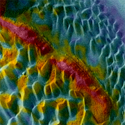
Edge of the Pit
The eroded edge of the crater's floor layer cuts diagonally across this image, its red color indicating exposed rocky material. Elsewhere within the big image, reddish colors trace other parts of this floor layer - for example, at the top and bottom right of the picture.
The origin of the crater floor layer is unknown. Impact melt - rock liquified by the impact making Rabe Crater - or a sheet of ancient lava are both unlikely. The layer appears to erode more easily than lava or hardened impact melt, and its spectrum has a different mineral signature. More likely origins include a layer of volcanic ash that fell from the sky and became compacted, or debris that either blew or washed into the crater before solidifying.
Lying below this layer is a broad, dusty depression, colored blue in the big image. This ground lies roughly 1 kilometer (3,300 feet) lower than the crater floor level and forms part of a set of connecting hollows that merge to make a large pit in Rabe's floor.
As with the crater floor, the pit's origin is uncertain. Scientists, however, lean toward two explanations: water erosion and excavation by wind-blown rock and sand particles. Both forces may have been at work, and the result would be a hole in the ground, plus a lot of loose material, some of which could form dunes.
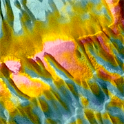
Dunefall
Covering much of the crater floor is a washboard- texture of sand dunes. The dunes' height ranges from 150 to 200 meters (500 to 650 feet) or more, and studies of their composition indicate the sand grains are basalt, a very common volcanic rock.
As seen by THEMIS, most of the dunes show a temperature range; dune crests appear yellow, while troughs are generally blue. The explanation is that the tips of the dunes are warmer at night (by about 6° Celsius, or 11° Fahrenheit) because winds have swept them largely free of dust.
Bare sand and coarse grains hold daytime heat slightly better than fine dust, so the dune crests don't get quite as cold as the troughs, where dust has collected.
In this close-up view, a "waterfall" of dunes and coarse material is spilling over the lip of the floor layer into the depression at the top of the image. High-resolution photos with the MOC imager on Mars Global Surveyor show boulders on the slope, hinting that the crater floor layer is actively shedding rocky debris.
Between a few dunes, you can catch glimpses of the flat crater floor. But it is covered with enough dust to look as blue (cold) as the dune troughs themselves.
By their shapes, dunes signal which direction they have migrated. As dunes move, they develop a long, low ramp on the upwind side, and a short, steep slip-face on the downwind side. Looking at the big image, it's clear that winds shaping these dunes have blown generally from lower right (southeast) toward the upper left.
In some places, however, the pattern shows that winds have swirled around outcrops and ridges, pushing the sand in different directions.
Could the dunes ever fill up Rabe Crater's pit? Scientists estimate the dune field's volume is less than that of the large pit. This suggests it's possible that the dunes are simply pit debris blowing around the floor of Rabe, with some of it slipping back into the hole from time to time.
Similar pits and dune fields occur in several other craters in this section of Mars. But why this region should be different from others on the planet is not clear. Nor do scientists yet have a good explanation why many craters in this area have similarly flat floors.